Thanksgiving Weekend in the PNW
- Rob England

- Dec 3, 2020
- 9 min read
Updated: Jan 10, 2021
Thanksgiving looks different for all of us this year, there's not question about that. Many of us, including myself, were unable to visit family or friends like in years past. It's tough not being able to do much about that with our current state of affairs, but like everything, there is always a silver lining.
I know for myself, I will never take another holiday gathering for granted. I was expecting to be ~2500 miles away from most of my family and friends, but unable to visit because of a virus? That wasn't even a thing that had ever crossed my mind. Anyways, onto that silver lining...
The biggest difference between Washington and Vermont is the elevation of the mountains, which happens to have a direct positive correlation with snowfall because, you know, that's how elevation works. It's also one of the critical reasons I picked the PNW for my move. If you know me, then this is no surprise. Upon arriving back from my long weekend in Montana, I immediately starting reading up on NWAC for pre-season reports before the official avalanche forecast postings starting on November 25th. There is a fairly dedicated outdoor community here and everyone seems to be open to sharing general information on conditions, especially to keep everyone safe. There were a bunch of observations listed from all over the Cascades on early season conditions, and with the more official avalanche forecasts from the full-time team at NWAC, it gave a quality overview on what to look for when you got out there. As the sign on I90 said, "snow in places", and I made it a goal to confirm that there was in fact snow in places - tough job, but somebody has to do it.

Early season avalanche forecast for Snoqualmie Pass area
I was out in Snoqualmie Pass, at Alpental, on Thanksgiving and there were quite a few other people out getting some pre-season turns, sledding, or simply hiking around the resort. Weather report: temps hovered right around freezing, overcast skies, and this persistent layer of fog that seemed to be stuck in the canyon (not sure if that's what I should call it but we're sticking with it). The fog was not ideal for my first day being at Alpental, but I had spent several hours on CalTopo and Google Earth looking over the terrain and cross referencing with trail maps in case I made it up there in this exact low-visibility situation, so I was relatively prepared. I did learn a few things, we'll get to those later. Heavy, wet snow caked the resort. Primo base building snow. Not so primo early season, legs-not-used-to-skiing-yet, snow. The tour up was easy, there was one main track that followed the Sessel lift up, but there were many offshoots. It was a free-for-all in some spots, a lawless land of indecision.
Getting to the top of the Sessel lift, I got my first glimpses of the rock face that sits above the resort as the fog lifted for a few minutes. Jagged rock, large cliffs, and extreme terrain. Just past the top of the Sessel lift is where the skin track became incredibly questionable. The main track took a direct route toward a couple of black diamond trails (~40 degree slopes), traversing them horizontally, directly below the rock face, crossing multiple chutes coming off the face - in other words PRIME avalanche terrain. I stopped about 300m from the left turn to the traverse and made the decision to not go further. This is the moment I learned that most people set some ridiculous skin tracks with no regard for hang fire or terrain below them. A chilling reminder to trust exactly zero people outside your group, especially this year with an almost certain increase in backcountry trips by less than knowledgable skiers and riders.

Blue line: rough outline of skin track, Red arrows: chutes (behind trees), prime avalanche terrain
I have no problem with more people in the backcountry, I actually encourage people to get out and experience the terrain outside the resort; however I always make it a big point to get the education, take an avy course, get the gear, learn how to use the gear, and practice, practice, practice. Surviving an avalanche is not something you learn from experience, it is 100% preparation and reducing risk. And, just buying the standard beacon, shovel, and probe is not going to help you if you don't know how to do a proper beacon search, or understand the urgency of the situation at hand. I've made it a habit to wear my beacon everyday I am on my skis, resort or backcountry. It's better to have it and not need it than not have it and be buried under a meter of snow with less than 15 minutes of air. Ok, that's my rant. Back to the skiing...
As I was saying, I stopped touring well before the top. I had only gone about 700 vertical feet, Strava says that I was at ~3850ft, Suunto says 1170m, where I stopped to transition to downhill. I figured a quick probe of the snow depth was in order. ~170cm in one spot and ~120cm in another. Pretty impressive for Thanksgiving day! I did not dig a proper pit, but on several probes there seemed to be a crust at 15cm, 50cm, and 80cm from the base (that's 105cm, 70cm, 40cm from the surface at 120cm). The rest was not firm. Without digging a proper pit, I cannot say what those layers represent, or if they were in fact real layers, but I didn't want to dig a 4'x4' hole to the ground in the middle of the resort, so my notes will stay as is and they will be "layers" for further evaluation.

Not a bad start to the season in WA
The ski down was really quite fun! The snow was heavy, but poppy. Still getting used to the new skis and the weight of them, and getting used to skiing with a pack, is a bit of a learning curve for me as well. Might need to find a way to reduce pack weight. I tend to travel on the heavy side because if I need something, I want to make sure I have it, although it may be a bit excessive when touring in-bounds at a ski resort. Not sure, will need to re-visit this thought later.
The run down was so nice that I opted to tour back up for round two! I picked a different skin track, this time following the Armstrong Express. I was putting in my own skin track for a little bit until I caught a more well-defined track about 3/4 the way up the first pitch. At ~3700ft, I reached a creek crossing - the usual mountain resort creek situation. As I looked at the creek and above, I couldn't see much more than 100m because of the fog and I wasn't sure exactly what the terrain, snow coverage, or other potential early season obstacles were ahead. So, once again, I opted to stop my upward progress on this pitch. I cut back across toward the Sessel lift and caught the first skin track I was on until I cut right and up about another 100ft before finding a flat spot to transition to downhill. There were no speed records broken, it was a low and slow kind of day, building up that baseline for fitness for a long winter season (and potentially summer Mount Rainier, Baker, Hood, St Helens...oh, the possibilities).
Well, that was day 1. If you're still with me, cheers, get yourself another drink or some hot cocoa, or I don't know, eat a cookie. We have three more days to the longest holiday weekend of the year.
Friday was again spent at Alpental, however the weather was on my side this time. Sunny, blue skies, 35 degrees, light breeze, absolutely incredible weather, and visibility was 100% with 0% fog. With the great weather, something had to give, and that was the snow. Everything froze over night, leaving the previously packed skin tracks super slick and adding a firm crust to any snow that was untouched. The crust was soft enough to break through with a little effort, but firm enough to crunch and create chunks. My Strava title for the day pretty much sums up the experience: "when the skin track is ice, make a new one". I put in a track following the iced over track for most of the way up, needing to add my own variations with switchbacks or new lines in certain places to make it substantially easier as my skins were not having a good time sticking to the ice. Although the air temp was 35 degrees or so, most of Alpental faces E/NE leaving it in the shade for much of the early winter days. There is also a ridge to the south, making Alpental into a bowl of sorts and preventing much of the sunlight from warming the slopes. Learned a lot about setting a skin track, hoping that it is useful later this winter when I am venturing out into more remote areas. Note to self: breaking trail is kind of fun because it's a choose your own adventure of sorts, but also not fun because if you choose wrong then you're going to have a bad time.

View looking back east toward the base of Alpental

Strava map from day 2 at Alpental, getting a bit higher in the alpine
Saturday was a down day. I spent the day editing, printing, and mounting photos for a few shipments that I'm hoping to get out this week. I've also rediscovered running and it is a great way to break up the day. I found that if I get anxious or lose focus for any reason, just lace 'em up and do a quick 5k and. Boom. Back on track (no pun intended).
Sunday, the 29th. Rediscovering something I don't enjoy as much as running: kick turns. Kick turns could be one of my least favorite things while touring. I'm not sure if it's because I've never needed to do them and I am really bad at them, or if it's the awkward leg twisting that goes into a kick turn. I don't know. What I do know is I need to practice them because wow touring up steeper slopes and not being able to kick turn makes it very difficult.
The Skyline Trail, across from Stevens Pass Ski Resort, was the destination to close out the weekend. Having toured and skied there in January, I knew the way up would be easy to the tower or lake. I opted for the tower route and found a trail that continued up the ridge line. I had looked over this area on CalTopo and Google Maps, just as I have done for numerous zones I'm looking to explore, and I knew this was an area I'd like to potentially ski later in the year so I figured following this trail and getting a better look would help me put together routes later. There is only so much looking on the internet that you can do, you really need to get there in person a few times before you can really understand the terrain you are in. I was on high alert the whole way from the towers to the peak. I don't know if it is just a peak or a ridge line, not sure of the name of it either, but it is on an elbow of the boundary to the Mount Baker-Snoqualmie National Forest (King County) and the Okanogan-Wenatchee National Forest (Chelan County). Either way, the tour from the tower to this peak was less than fun. The skin track was riddled with steep switchbacks, leading me to break my own trail to find a better way. I have no idea who put this skin track in, but they must be extremely adept in touring because it was miserable for someone who is simply competent with ski touring. One thing I did learn: I need to practice kick turns, as noted above. The first 1000ft of elevation gain to the towers took about 50 minutes, the remaining 350ft to the top of the ridge took another 50 minutes. It was rough. It became more of a mental battle with a lot of breaks and talking myself through moving step by step up the mountain. The peak was ~5400ft according to Strava and it seems like a good ridge starting point for a few skiable options on the north side, eventually linking up with the PCT. I will likely ski off of Heather Ridge just the east of this ridge first. Heather Ridge will lead to a longer traverse out, but the terrain is much more mellow and less apt to be in avalanche danger due to the much shallower slope angle. If you haven't noticed, I'm really all about reducing risk here. There is a time and place to have risk, some of these situations are simply not the right time or place to take any sort of chances.
The one benefit of reaching this peak was the views. It was another bluebird day, 5-10mph breeze, ~35 degrees. Got a few glimpses of Mount Baker to the north, reminding me just how prominent the stratovolcanoes are in the PNW. A truly remarkable fact of Earth, and one that I really enjoy being able to see.
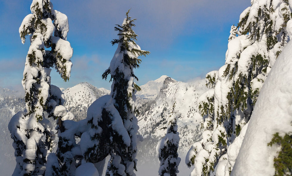
Bluebird day, great views, Mount Baker off to the north

Sometimes you just need to stop, look up, and enjoy nature

View to the south toward Stevens Pass

Strava map of my tracks
With all the views on the bluebird days, I have a bunch of photos to go through which is exciting. There should be a few new items in the shop and on Flickr in the next week or two! I'll likely dedicate a couple of posts to a few groupings of photos that I really enjoy and maybe one post will my favorite shots from 2020 (one post will almost certainly be dedicated to volcanoes).
As always, feel free to reach out and connect. Cheers.


Comments